E-ISSN:2583-2468

Research Article

Global Regions

Applied Science and Engineering Journal for Advanced Research

2023 Volume 2 Number 2 March
Publisherwww.singhpublication.com

Global Regions, Biological Diversity, and Urban Land to Significance

Vyas A1*, Dwivedi R2
DOI:10.54741/asejar.2.2.1

1* Alka Vyas, Associate Professor, Department of Zoology, MMH College, Ghaziabad, Uttar Pradesh, India.

2 Rakhi Dwivedi, Associate Professor, Department of Chemistry, MMH College, Ghaziabad, Uttar Pradesh, India.

As the world's urban population is expected to grow by 2.5 billion over the next 30 years, urban land conversions are likely to become a bigger cause of habitat and species loss. It is vital to gain a better understanding of the potential locations and mechanisms for these biodiversity losses in order to mitigate their impacts. In this study, we assess the projected habitat loss due to urban land expansion for 30,393 species of terrestrial vertebrates from 2015 to 2050 across three shared socioeconomic pathway (SSP) scenarios using a recently developed suite of land-use projections. We discover that for about one-third (26–39%) of the species evaluated, urban land expansion is a contributing driver of habitat loss (5% of total loss). Urban land is a direct cause of species imperilment for up to 855 species (2–3% of those assessed), accounting for at least 25% of a net habitat loss of 10% or more. Sub-Saharan Africa, South America, Mesoamerica, and Southeast Asia are the major developing tropical regions where urban clusters are most likely to threaten species owing to anticipated expansion. Our findings imply that methods for reducing the effects of urban land could improve international agreements for the preservation of biodiversity. To mitigate the effects predicted by our analysis, cooperative, global action that prioritises vulnerable species and regions may constitute an effective tactic.

Keywords: biodiversity, land, species loss, urbanization, priorities, habitat loss, global areas

Corresponding Author How to Cite this Article To Browse
Alka Vyas, Associate Professor, Department of Zoology, MMH College, Ghaziabad, Uttar Pradesh, India.
Email:
Vyas A, Dwivedi R, Global Regions, Biological Diversity, and Urban Land to Significance. Appl. Sci. Eng. J. Adv. Res.. 2023;2(2):1-7.
Available From
https://asejar.singhpublication.com/index.php/ojs/article/view/43

Manuscript Received Review Round 1 Review Round 2 Review Round 3 Accepted
2023-02-10 2023-02-27 2023-03-19
Conflict of Interest Funding Ethical Approval Plagiarism X-checker Note
None Nil Yes 11.17

© 2023by Vyas A, Dwivedi Rand Published by Singh Publication. This is an Open Access article licensed under a Creative Commons Attribution 4.0 International License https://creativecommons.org/licenses/by/4.0/ unported [CC BY 4.0].

Introduction

Urbanisation will be one of the key changes of the 21st century, as the worldwide urban population is expected to grow by 2.5 billion people over the next 30 years. These increased urban populations will require significant urban land expansion, which frequently comes at the expense of natural ecosystems. This poses a challenge for sustainable urban growth at a time when the world's biodiversity is gravely threatened.

Plants and animals can live in cities, and most people agree that people need access to nature in order for cities to be useful and liveable for people. Yet, when urban land takes the place of natural habitat, it permanently changes the kinds of habitats that are available, as well as how they are arranged in space and how interconnected they are, which has a profound impact on the diversity and composition of species assemblages. The abundance of native species typically decreases as urban land use intensity increases. Invasive species are more common in urban settings, and their percentage often rises as cities become more urbanised. Moreover, urban terrain can promote phenotypic adaptations and hasten ecoevolutionary change. The reduction in global biodiversity is a result of these effects on the biota. For instance, between 1992 and 2000, habitat lost due to urban land growth amounted to over 190,000 km2, or 16% of all habitat loss during this time. Around 8% of the terrestrial vertebrate species included on the IUCN Red List of Endangered Species are thought to be largely in danger as a result of urbanisation.

Even though urban land growth seems to be a big reason for habitat loss, there has been no global response to this problem. The Aichi Biodiversity Goals of the Convention on Biological Diversity (CBD), which are no longer in effect, and other international agreements to protect biodiversity have focused on the loss of habitat caused by agriculture and forestry. Still, by ignoring the growth of cities, a source of habitat loss that could be very important is being overlooked.

Understanding the size and location of these effects in the future is important for coming up with a social response to how cities affect biodiversity. Predictions of the effects of urbanisation on biodiversity can show how important urban land is as a cause of habitat loss.

By identifying particularly susceptible species or areas where impacts will be most concentrated, they may also offer insights that help with the implementation of targeted and effective interventions. 290,000 km2 of natural habitat will probably be lost to urban growth between 2000 and 2030, based on what is known about how cities are growing around the world.

This includes putting more than three times as much city land next to protected areas. It is expected that a lot of this urban growth will happen in places with a lot of different kinds of life, or "biodiversity hotspots." In 2000, many of these places had very little urban area. This is anticipated to cause losses in ecoregional endemic species, 13% of which are found in ecoregions where urbanisation is forecast to pose a serious danger.

Even though these analyses have shed light on how future urban land could affect biodiversity, they are limited in four important ways that make them less useful and less wide-ranging. To start, they have a coarse spatial resolution. It is challenging to identify the main players and their roles because they frequently discuss the effects of urban land at an aggregated scale (countries or bioregions) that may fall under the purview of several authorities tasked with biodiversity conservation. They also have poor taxonomic resolution.

They frequently make generalisations about species that might have diverse reactions to urban growth. Thirdly, they emphasise the effects of urban land without accounting for potential habitat loss outside of the metropolitan area.

For instance, combined habitat loss from urban and agricultural land growth may result in species extinction where these two land uses do not do so individually. Last but not least, current studies typically only anticipate implications out to 2030 or so.

As this date draws closer, these forecasts lose their usefulness, necessitating the need for an updated set. We compare a scenario for sustainability (SSP1), a scenario for conflict between regions (SSP3), and a scenario for development based on fossil fuels (SSP5). SSP1 imagines a way to get to sustainable development where there isn't much population growth, less consumption, a lot of food from agriculture, and good regulation of how land is used.


Contrarily, under SSP3, which is characterised by rapid population growth, high rates of material consumption, low agricultural output, and lax land-use control, environmental constraints are significantly larger. Under SSP5, the world trusts in markets and technical advancements. Moderate levels of environmental pressure are brought on by rapid economic growth, a peaking and declining population in the twenty-first century, and poorly regulated land use that slowly slows the rate of tropical deforestation. By the end of the century, 92% of the population is forecast to live in urban areas under SSP1 and SSP5, compared to 60% under SSP3. We demonstrate that differences in the level of urbanisation and anticipated land-use pressures are likely to have quite divergent effects on biodiversity. By offering a thorough set of forecasts of the effects of urban area expansion on certain species, we hope to remedy these limitations. We identify the species and geographic areas that would experience the greatest habitat loss as a result of urban land development. We evaluate each urban cluster's contribution to habitat loss and identify urban impact hotspots. In this review, we emphasise the significant implications of our findings for global biodiversity conservation methods and sustainable development goals.

We used newly made, spatially clear projections of urban land to estimate how much habitat 30,393 species of land-based vertebrates will lose due to the growth of cities between 2015 and 2050. In order to give a more precise indication of whether the reported habitat losses due to urbanisation are causing each species to be imperilled, we also estimate the amount of habitat lost due to nonurban land-use change for each species. The projected species area scores of the Species Habitat Index are comprised of urban and nonurban habitat loss relative to the 2015 baseline. We evaluate forecasts of land-use change under three shared socioeconomic paths (SSPs), which represent potential alternative trajectories in the evolution of society and natural systems over the 21st century, in order to account for the enormous uncertainty in the likely amount of new urban land.

Discussion

By predicting global habitat losses, we hope to learn things that will help guide the growth of cities in the future.

Our findings show that although changes in agricultural land use would be predominantly responsible for worldwide habitat loss, habitat losses that directly endanger some species will also be caused by continuous expansion of urban areas.

asejar_43_01.jpg
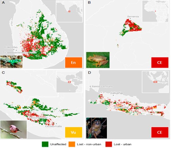
Figure 1:
Habitat loss is anticipated as a result of SSP-1 land-use change in urban and nonurban areas by 2050.

In our analysis, we focus on these species and the fact that they are becoming more and rarer in cities. Here, we talk about our research's implications for biodiversity preservation worldwide in the face of urban area growth.

Priorities for Urban Conservation

Our findings demonstrate that a small subset of urban clusters, accounting for roughly one-third of the total anticipated new urban area, are responsible for at least 70% of the urban-driven HSR loss forecast for severely endangered species.

asejar_43_02.jpg
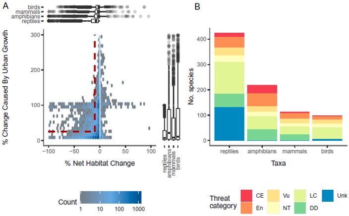
Figure 2:
For all terrestrial vertebrate species impacted by urban land expansion under SSP1, the relative range loss attributable to urban vs.


all anthropogenic land-cover change is summarised (n = 21, 111). (Across the three SSPs, 23–37%) An effective conservation strategy that targets global urban conservation efforts towards species and locations that we expect will be most at risk from urban expansion can take advantage of this concentration of consequences.

We list all of the species expected to suffer a negative impact from urban land growth in the supplemental materials, as well as the urban clusters that are to blame. In 2015, our study shows that these species have a small range size and a small HSR, which means they have limited habitat within that range. This is demonstrated by the fact that the IUCN Red List has already classified about one-third of the most severely damaged species as threatened. Geographically speaking, urban clusters with the greatest consequences are found in areas of endemism, where a higher percentage of species have confined ranges.

Island countries like Sri Lanka and Indonesia, which have a lot of species that are only found there and don't live anywhere else, are especially at risk from future urban growth.Rapidly urbanising equatorial regions, including those in sub-Saharan Africa, South America, Mesoamerica, and Southeast Asia, are where urban impact hotspots are most prevalent. These are the areas where future biodiversity declines are most likely to occur, according to earlier studies.

Our findings imply that safeguarding the habitat of endemic and range-restricted species in these rapidly urbanising areas may assist in the targeted protection of the species expected to be most vulnerable to urban land expansion. Such activities might be carried out on a worldwide level by incorporating priority regions into agreements on the conservation of biodiversity, like the CBD's Post-2020 Agreement, or by directing global conservation funding from sources like the Global Environment Facility. Global strategies can assist focused local action as national and subnational governments create regulations to direct conservation efforts inside their spheres of influence. Many of the urban impact hotspots are located in areas with weak institutional and financial capacity as well as weaker governance structures, which may limit the ability to mitigate the effects of urban land expansion on biodiversity. This will be a significant challenge for these localised efforts.

Urban Land Conservation Worldwide

According to our findings, each of the three SSPs examined will result in global habitat loss that will endanger species. The species highlighted by our study can benefit greatly from approaches to global conservation that recognise the significance of urban land-use change as a driver of habitat loss. The preservation of species in the face of urban land growth will be extremely difficult. Due to lowering global population densities, urban land is expanding at a quicker rate than urban population growth. It is anticipated that this tendency would persist over the ensuing decades, with implications for more comprehensive and sustainable urban development. According to our analysis, if these trends continue, more urban space will be needed to accommodate an increase in the urban population, which could have an influence on biodiversity.

For most of the species looked at, habitat loss is mostly caused by urban clusters, which often span several cities and/or national borders governments. When cities, states, or nations work together to protect these species, the effects of habitat loss brought on by urbanisation are likely to be less severe across a species' range. This coordination can be made easier by global frameworks for conservation and sustainable urban development. However, global agreements have so far done a poor job of addressing the effects of urban land expansion on biodiversity.

In line with the Sustainable Development Goals (SDGs), the United Nations Human Settlement Program's (UN-Habitat) New Urban Agenda (NUA) sets up a plan for sustainable development in cities. These comprise objectives that seek to lessen the negative effects of urban land use on biodiversity through promoting biodiversity planning and limiting urban sprawl.

However, the Intergovernmental Science-Policy Platform on Biodiversity and Ecosystem Services cites the ongoing loss of significant habitats caused by urban expansion within global biodiversity hotspots as a significant challenge for achieving sustainable urban development targets outlined in the SDGs. This is true even though the NUA was introduced in 2016. As the world enters the Decade of Action to deliver the SDGs by 2030, our findings underscore UN-Habitat's call for a renewed commitment to the NUA's goals.


International agreements about biodiversity have also not talked enough about the need to manage land in cities. Historically, the threat posed by urban land has been eclipsed by the pressing need for reform in other, more pervasive land use sectors, such as agriculture and forestry.

Urban land development's role as a cause of habitat loss was not explicitly acknowledged by the CBD's Aichi Biodiversity Objectives, which were set to expire in 2020, and the current draught of the post-2020 global biodiversity framework does not address this omission.

Urban land management might be incorporated into the post-2020 agreement, and there could be a renewed emphasis on putting the NUA into practise. This could make it easier to coordinate worldwide efforts for urban conservation that direct national funding to local urban conservation policies. City cooperation might also be made easier.

asejar_43_03.jpg
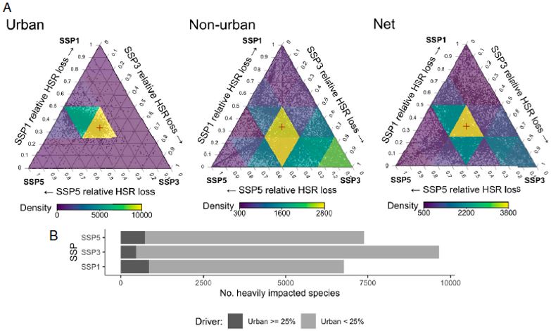
Figure 3:
The proportional HSR loss is presented across the three SSP scenarios driven by urban (left), nonurban (pasture, agriculture, and forestry, middle), and net (urban and nonurban, right) land-use change for all species impacted by urban land expansion under at least one SSP (grey background points, n = 19,837).

Through voluntary multicity networks that allow cities to collaborate to advance sustainable development goals, such as Local Governments for Sustainability.

Questions are still open, and research priorities exist. Our analysis shows urban land's possible direct effects as a driver of habitat degradation over the ensuing 30 years. While habitat loss is undoubtedly the most significant factor driving the loss of biodiversity worldwide, cities also play a direct and indirect role that was not taken into account in our study.

Invasive species introduction and habitat fragmentation are two additional direct effects of urban land use in addition to habitat loss (36). Cities' consumption of resources (such as food and building materials) and production of trash (such as greenhouse gas emissions or industrial waste) can have a direct or indirect impact on environment. Indirect effects are those that are mediated by an intermediary process. By teleconnecting urban resource demand to habitat destruction around world, these effects may be felt well beyond confines of urban regions. Climate change-related hazards to biodiversity coexist with urbanisation, but our study does not address these threats. Over projection period, climate changes are likely to cause some of species in our evaluation to move their geographic ranges. Certain temperature-sensitive species may not be able to live in metropolitan regions due to urban heat island effect. Wildlife populations may experience challenges from climate change that increase their susceptibility to habitat loss, such as disruptions to breeding cycles or food availability. This will change results of our examination in unpredictable ways.

Also, we know enough about the locations and preferred habitats of a small group of land-based vertebrate species to be able to do our study. It is crucial to keep in mind that the species considered here make up a relatively small part of all species on Earth. We specifically do not evaluate the effects on plant or invertebrate species. As a result of a significant knowledge gap regarding how species would be able to utilise the urban landscape, our study also employs a crude binary classification for species' ability to adapt to urban territory. Our understanding of the effects of urbanisation on biodiversity will be strengthened by future research that examines the broader direct and indirect effects of urban land in a changing climate and across a wide range of species.

Materials and Methods

Data on Land use and Land Cover

By combining global categorical LULC forecast maps at 10-arcsec (300 m) resolution created for use in the GLOBIO 4 global biodiversity model for policy support (29) with URBANMOD-ZIPF, a probabilistic spatial urban land forecast at 5,000 m resolution developed by Huang et al., we create land-use and land-cover (LULC) maps for 2015 and 2050.


Based on SSP scenarios, both datasets anticipate LULC through 2050 and provide a baseline estimate of its size in 2015. We define current and future urban land using URBANMOD-ZIPF because we think it more accurately represents urban land than the GLOBIO model. In order to distinguish between urban and rural settlements, URBANMOD-ZIPF includes minimum thresholds for population density, size, and built-up area. Additionally, it explicitly maintains Zipf's law, which is the log-scale size distribution of future urban clusters. The expected area of new urban land is calculated throughout this analysis by multiplying the URBANMOD-ZIPF probability values by the pixel size.

Analysis of Land Cover

Using Google Earth Engine, we add the area of new urban land expected according to the URBANMOD-ZIPF forecasts for SSP1, SSP3, and SSP5 in six of the continent's most important regions. We compare the URBANMOD-ZIPF urban land forecasts for SSP1, SSP3, and SSP5 to the 2015 gHM map in order to understand the level of modification that land currently has that is expected to become urban by 2050. Within each continental region, we add up the area of new urban land that is expected to be built on land with varying degrees of change, from 0 (completely natural) to 1 (completely changed), in 0.1-unit increments. Google Earth Engine performs area calculations at the scale of the gHMmap (1 km).

analysis of species.

We use a method that Powers and Jetz (20) developed to estimate the change in each species' HSR between 2015 and 2050.The global species area part of the Species Habitat Index is predicted here. This part links the HSR of a reference period to that of a later time.Experts refine range maps based on the LULC categories and elevations that each species prefers. This helps them estimate HSR for each species. The 2015 GLOBIO and URBANMOD-ZIPF maps are used to figure out how much land is in cities, and the 2015 GLOBIO LULC map is used to find values for the rest of the land that is not in cities. We use this map as a base to make a HSR map for each species in 2015 by masking any LULC classes that don't match the species' preferred habitat and clipping to the extent of the expert rangemap and known elevation range for the species.

The International Geosphere-Biosphere Programme land-cover categorization scheme is used to categorise the species' habitat preferences, and we match them to the LULC classes in our 2015 LULC map, as detailed in the SI Appendix.

Hotspots of Urban Impact Identification

We want to find the places where urban land is a big reason why species are becoming endangered. By concentrating on the clusters that account for the biggest share of the anticipated HSR loss among severely damaged species, we categorise a set of urban clusters as urban impact hotspots. We use prioritizr package in R to create an optimum method for locating these clusters, allowing us to pinpoint minimum number of urban clusters that account for roughly 75% of the HSR lost to urban clusters for each severely afflicted species. In order to do this, we use Google Earth Engine to compute proportion of each species' 2015 habitat estimated to be lost to each urban cluster and then import the results into R. We define a minimum set of problems using prioritisation and urban clusters as planning units. We assign each cluster an equal "cost" and set a relative aim of 75% HSR loss.

Conclusion

Our findings show how, in several scenarios, predicted urban land expansion would affect biodiversity around the world over the next 30 years. We demonstrate that urban land, together with other factors like agriculture and forestry, is likely to be a major cause of habitat loss. But our findings also offer a course of action. Concentrating worldwide efforts on high-priority species and areas might be an effective way to minimise impacts on biodiversity while spending little money and effort on conservation. Our findings highlight the significance of incorporating urban land impact mitigation measures into biodiversity conservation efforts at all scales, from the global to the small.

References

1. Gibb, & D. F. Hochuli. (2002). Habitat fragmentation in an urban environment: Large and small fragments support different arthropod assemblages. Biol. Conserv., 106, 91–100.

2. L. McKinney. (2006). Urbanization as a major cause of biotic homogenization. Biol. Conserv., 127, 247–260.


3. I. Mcdonald, P. Kareiva, & R. T. T. Forman. (2008). The implications of current and future urbanization for global protected areas and biodiversity conservation. Biol. Conserv., 141, 1695–1703.

4. Harrison, P. A. (2010). Ecosystem services and biodiversity conservation: an introduction to the RUBICODE project. Conserv, 19, 2767–2772.

5. Jetz, J.M.McPherson, & R. P. Guralnick. (2012). Integrating biodiversity distribution knowledge: Toward a global map of life. Trends Ecol. Evol., 27, 151–159.

6. C. Seto et al. (2012). Urban land teleconnections and sustainability. Proc. Natl. Acad. Sci. U.S.A., 109, 7687–7692.

7. Beninde, M. Veith, & A. Hochkirch. (2015). Biodiversity in cities needs space: A meta-analysis of factors determining intra-urban biodiversity variation. Ecol. Lett., 18, 581–592.

8. C. Urban et al. (2016). Improving the forecast for biodiversity under climate change. Science, 353, aad8466.

9. C. O’Neill et al. (2017). The roads ahead: Narratives for shared socioeconomic pathways describing world futures in the 21st century. Glob. Environ. Change, 42, 169–180.

10. van Vliet. (2019). Direct and indirect loss of natural area from urban expansion. Nat. Sustain., 2, 755–763.

11. Jung, M. et al. (2021). Areas of global importance for conserving terrestrial biodiversity, carbon and water. Ecol. Evol., 5, 1499–1509.

12. GLOBIO, Data from “Available GLOBIO4 scenario data.” GLOBIO. www.globio.info/globio-data-downloads. Accessed 2 March 2022.